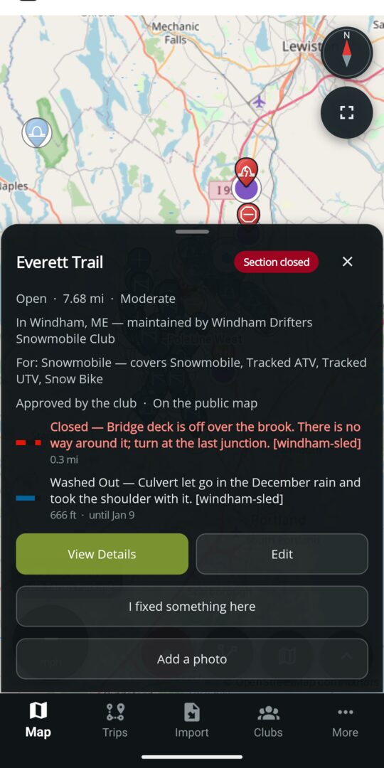
A closure is posted
A Closed stretch, thin ice or open water on a published trail, a trail or system set to closed, or a season closing. Free.

Map guide
A club posts a closure, a condition or a rule once, on the stretch it applies to. Every route, every alert on the ride and every notification follows from it. This page lists the markings a club can post and what each one does.
Posting markings, reviewing what riders send and keeping the map current are free for every club.
Looking for one task, step by step? See the how-to list.
Your club posts it once
A club can put information on the map three ways.
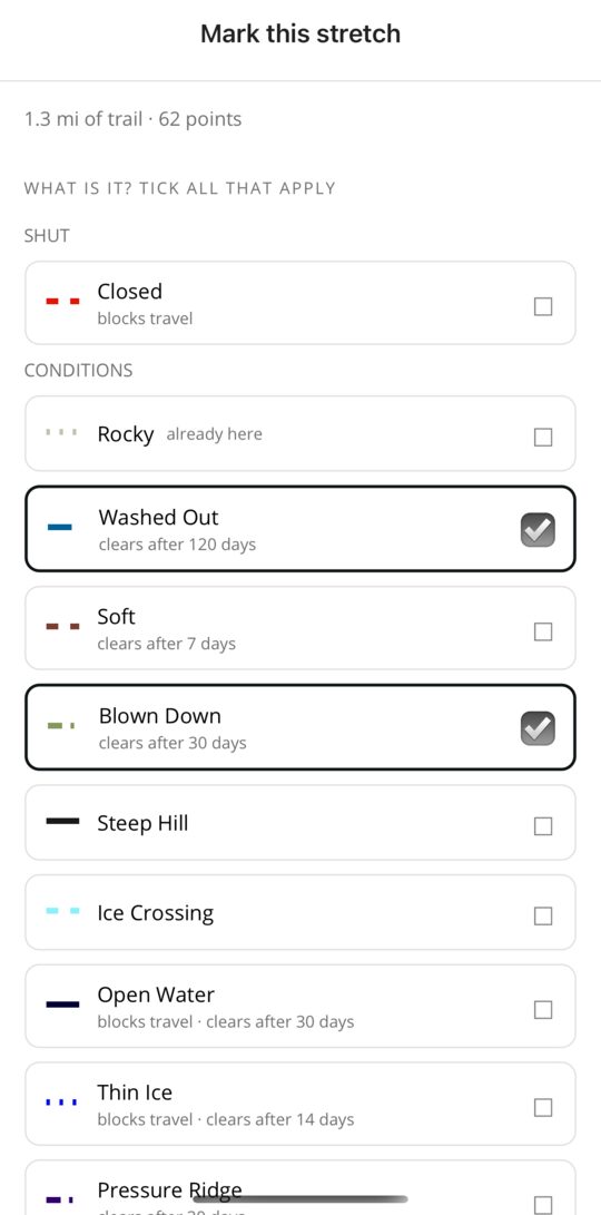
Several markings can go on one stretch at once. A Trail Master or Officer posts them directly; a rider can suggest them, and the club decides. Marking works with no signal and sends when you have coverage again.
Every marking is one of three kinds. A closure means you may not ride here. A condition tells you what to expect. A rule is how the club wants the stretch ridden, and it stays until the club changes it. Each one carries a note, and conditions carry an expiry date so last spring's washout does not outlive the repair.
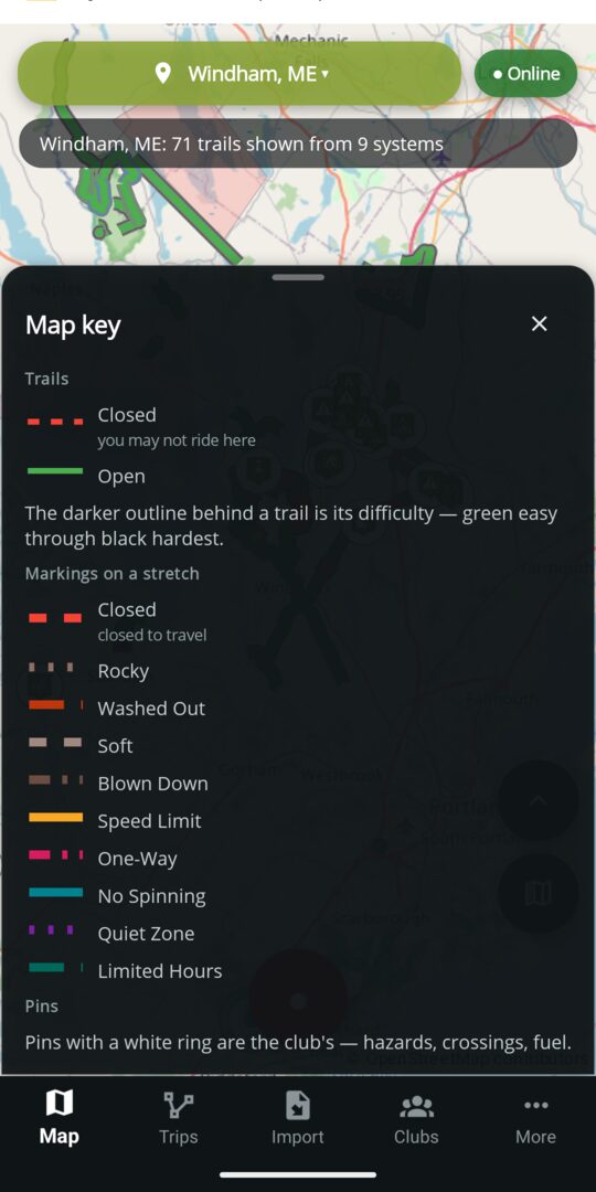
Each marking has its own color and dash pattern, and the key lists only the ones on the map in front of you. High-contrast markings switch to a palette built for color-blind riders, and marking letters put a two-letter code right on the stretch.
Clubs can add marking types of their own. These come with every club.
Pick any marking in the tables below to see it drawn on a trail.
| Marking | Kind | What it means | Expires by default | Blocks travel |
|---|---|---|---|---|
| Closed | Closure | You may not ride this stretch. | When the club says | Yes |
| Rocky | Condition | Loose or exposed rock on the stretch. | No expiry | No |
| Washed Out | Condition | Water took the surface or a culvert. | 120 days | No |
| Soft | Condition | Mud or soft ground; expect ruts. | 7 days | No |
| Blown Down | Condition | Trees across the stretch. | 30 days | No |
| Steep Hill | Condition | A grade worth knowing about before you start up it. | No expiry | No |
| Marking | What it means | Expires by default | Blocks travel |
|---|---|---|---|
| Ice Crossing | The trail crosses ice here. | No expiry | No |
| Open Water | The ice is gone on this stretch. | 30 days | Yes |
| Thin Ice | Ice too thin to cross. | 14 days | Yes |
| Water on Ice | Standing water over the ice. | 14 days | Yes |
| Pressure Ridge | A ridge across the crossing; cross it square and slow. | 30 days | No |
| Slush | Slush on the stretch. | 7 days | No |
| Bare Ground | The snow is gone here. | 14 days | No |
| Drifted | Drifts across the trail. | 7 days | No |
| Icy | Hard, icy surface. | 7 days | No |
| Moguls | Whoops and moguls on the stretch. | 7 days | No |
| Marking | What it means | Carries | On a route |
|---|---|---|---|
| Speed Limit | The club's limit on this stretch. | A number, in mph | Noted; never blocks |
| One-Way | Ride this stretch in one direction only. | A direction along the trail | Followed on every route |
| No Spinning | No spinning tracks or tires here, usually a landowner's lawn or a soft field. | A note | Noted; never blocks |
| Quiet Zone | Keep the noise down past the houses, during the hours shown. | Hours and days | Noted; never blocks |
| Limited Hours | Open only during the hours shown. | Hours and days | Noted; never blocks |
Rules never expire on their own. Hours and days are shown as the club wrote them; a route does not guess what time you will get there.
These rules keep certain machines off one stretch, the way a posting keeps them off a whole trail. They all share one color on the map and are told apart by their letters.
| Marking | Offered on | Carries | Who it bars from the stretch |
|---|---|---|---|
| No Dirt Bikes | ATV trails | A note | Dirt bikes |
| No UTVs | ATV trails | A note | UTVs |
| No ATVs | ATV trails | A note | ATVs |
| No Oversized ATVs | ATV trails | A note | Oversized ATVs |
| No Tracked ATVs | Snowmobile trails | A note | Tracked ATVs |
| No Tracked UTVs | Snowmobile trails | A note | Tracked UTVs |
| No Snow Bikes | Snowmobile trails | A note | Snow bikes |
| Width Limit | Every trail | A width, in inches | Any machine wider than the limit |
| Weight Limit | Every trail | A weight, in pounds | Any machine heavier than the limit |
| Height Limit | Every trail | A height, in feet | Any machine whose rider entered a height over the limit; a warning if no height is entered |
A hundred yards of No ATVs does not close six miles of trail. The trail stays open, that stretch is off limits, and the rider is warned before reaching it.
The whole trail
A posting is the club's rule for a trail end to end, with a date window when it only applies for part of the year: Seasonal Closure, No Motorized Vehicles, Permit Required, Speed Limit, Width Limit, Weight Limit, Height Limit, and the machine bans: No UTVs, No Dirt Bikes, No ATVs, No Oversized ATVs, No Tracked ATVs, No Tracked UTVs, No Snow Bikes, No Snowshoes, No Mountain Bikes and No Dogs. E-Bike Allowed is the one posting that opens a trail rather than closing it.
A club can also set the days and hours a trail is open. Outside those hours the trail is drawn and announced as closed, and a route goes around it if it can. A Closed status or a marked closure always overrides the schedule.
A point on the map
Every club starts with these pin types. A pin's color says what kind of thing it is: red for what stops you or needs help, amber for what to take care over, blue for places and services, green for good news. When you zoom out, each pin becomes a dot in its color. Pick one to see it on a trail.
Clubs can add pin types of their own; a type with no picture of its own uses the plain pin.
A route is planned for the machine you ride. Tell the app what you are on, and the planner avoids every posting against that machine, every limit it exceeds and every closure. Planning is free. The planner reads every marking and posting on the trails it knows about, then applies these rules in order.
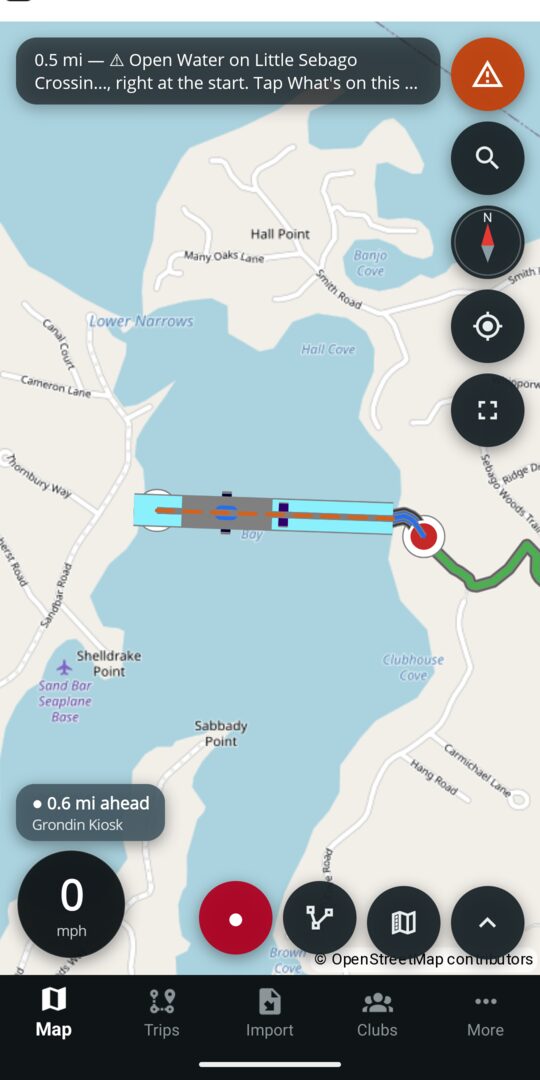
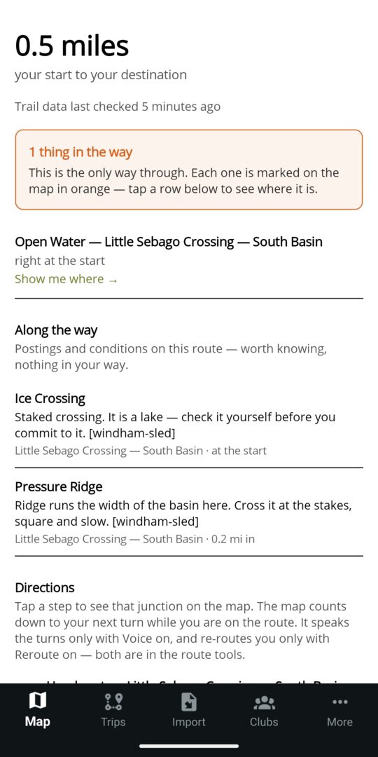
Every route comes with a list of what it crosses. Any closure it could not avoid is at the top, with a tap to see where; the postings and conditions along the way follow, each with the club's note. Change your machine and the map changes with it. The ride sheet lists every trail in view that is closed to your machine, grouped by reason, and a tap opens the trail with the club's own words.
Following a route turn by turn and saving routes are Premium. Planning a route, reading why one failed and seeing what is closed to you are free.
On the ride
While you ride, the app watches the trail ahead for the club's markings and pins and speaks up before you reach the ones that matter. The same rules apply on the phone, on Android Auto and on CarPlay.
Watch a trail system, or a whole state, and you hear about the club's decisions as they happen, whether or not the app is open.
A Closed stretch, thin ice or open water on a published trail, a trail or system set to closed, or a season closing. Free.
The club confirms a rider's report or publishes a new pin: a bridge out, a hazard, a gas station. Free.
A new trail is approved onto the club's map, or a trail file is imported. Free.
The club, the county or the state opens the season. Free.
A groomer run finishes on a trail you watch. Premium; the club's officers and trail masters get it free.
Each of these also appears in the trail system's Recent updates for ninety days, so a rider who wasn't watching can still see what changed.
Who vouched for it
Every trail, pin and area on the map says whether the club responsible for it has approved it. The wording is the same on the phone, the website and in the car.
A rider's own trails and pins stay on their phone until they choose Send to the club. Nothing a rider draws reaches anyone else's map until the club decides it should, or DynamicTrail does on a system no club holds yet.
Maine and New England clubs
Bring your club's map onboard and start marking what you know. Trail files and towns can follow later.