Everything the app does
DynamicTrail is the map your club maintains and your phone keeps working when the signal doesn't. Here is the whole of it — free, paid, and who each part is for. Nothing on this page is planned or coming later; it is all built.
Two prices exist on this page and no others: free, and Premium at $49.99 a year for a rider. See pricing.
For riders
Almost all of it is free. Where something is not, the row says so — and the full list is in the ledger at the bottom.
- free free forever, to anyone signed in
- Premium the rider subscription, $49.99/yr
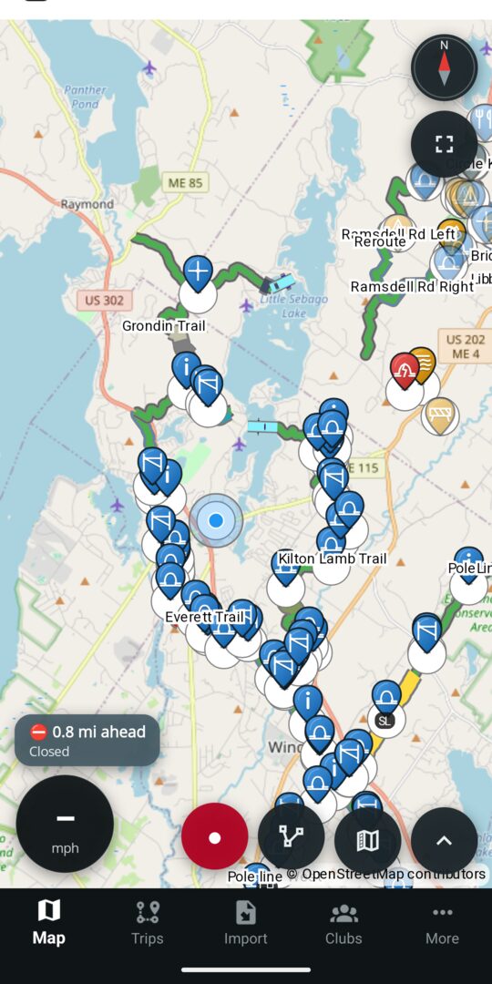
The map your club actually maintains free
Trails, waypoints, parking, warming huts and parcels — drawn from what the local club marked official, not from a crowd-sourced pile nobody owns. Closed stretches are red on the line, not buried in a post.
- Filter by activity — ATV, side-by-side, dirt bike, oversized ATV, snowmobile, tracked ATV, tracked UTV, snow bike, mountain bike, e-bike, hiking and cross-country ski — and by what a club allows on top, like e-bikes
- Several trail systems drawn at once, so a ride that crosses a club boundary still looks like one map
- Live groomer positions where the club shares them
- Contour overlay, satellite-free base map we host ourselves
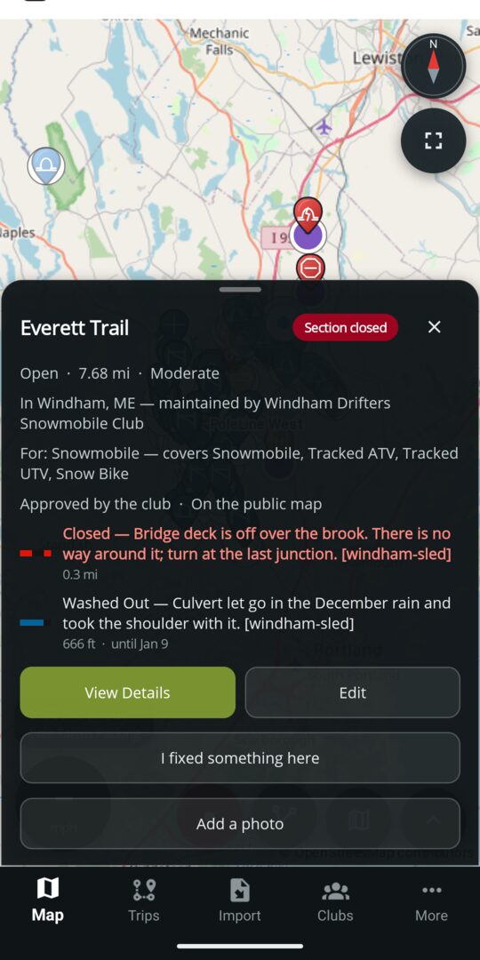
Tap a trail, see the truth about it free
Status, length, difficulty, who vouched for it, and every marking on it — closed, washed out, soft, blown down, one-way, speed limit — each on the stretch it applies to rather than the whole trail.
- Condition reports with a shelf life, so nothing stale stays on the map
- Reviews and ratings from riders who have been there
- Export any single trail as GPX or KML
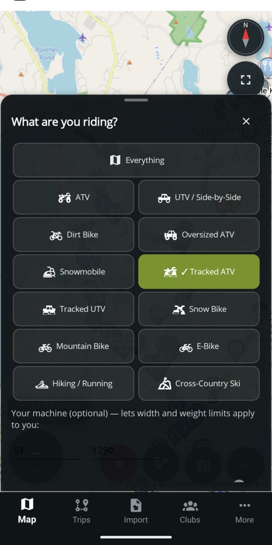
Tell it what you ride free
Pick your machine once and the map answers the question you actually have. Trails your machine is not allowed on go dim, and tapping one tells you why — Posted: No Dirt Bikes — using the restriction the club put on the trail.
- Twelve machines — ATV, side-by-side, dirt bike, oversized ATV, snowmobile, tracked ATV, tracked UTV, snow bike, mountain bike, e-bike, hiking and cross-country ski — or Everything, if you want the lot
- The count on the map is honest about what it hid: 2 trails shown · 2 not for your ride
- The same eligibility on the phone, on the dash and on this website
- Never gated. A posting a rider cannot see is a landowner relationship the club loses
- Saving several machines to your account and switching between them is part of Premium; one machine works free, forever, on the handset
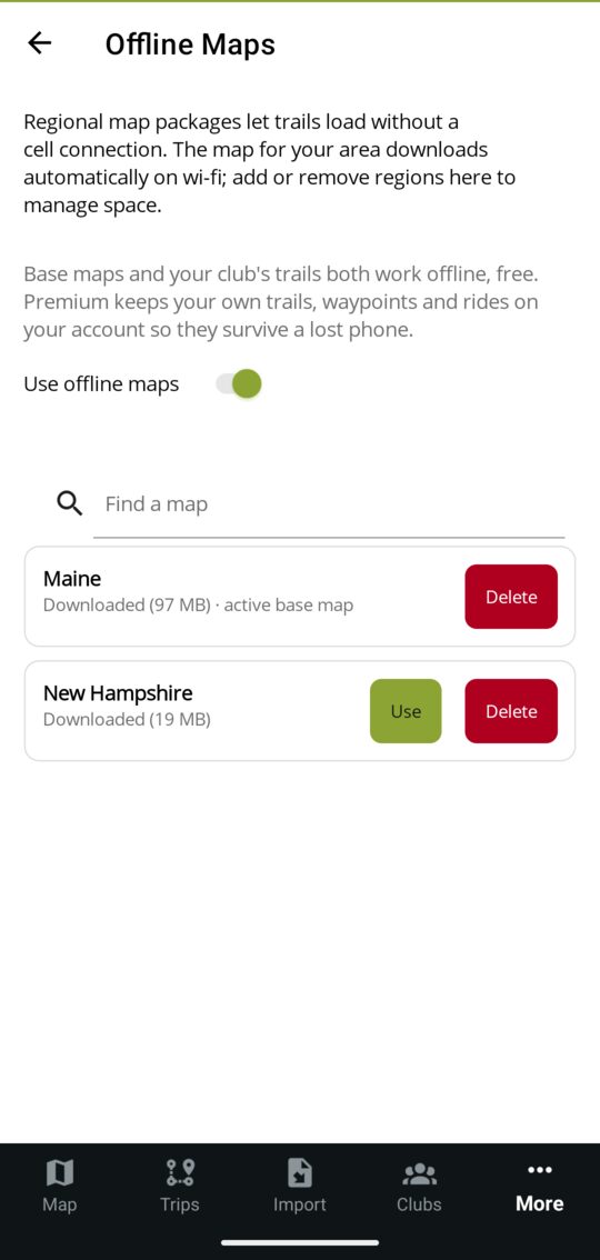
Works where the signal doesn't free
Your region's base map downloads once, about 100 MB, on wi-fi. Your club's trails, waypoints and closures are cached with it. No bars, no problem, and no subscription: paywalling the woods would be paywalling the point.
- Officers can edit trails and drop hazard pins offline; everything queues and syncs when coverage returns
- One region free, switchable whenever you like, and always free to keep current
- Premium carries several regions at once, for trailering out of state
- Maine and New Hampshire today, more states as clubs join
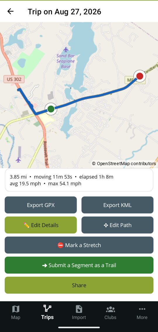
Record the ride, then do something with it free
GPS recording with pause and resume, distance, moving time and speeds, and the trails you actually covered matched automatically afterwards. It keeps recording with the phone in your pocket and the screen locked.
- Export it as GPX or KML, edit the path, or mark the stretch that was washed out
- Submit a segment as a trail — hand the club the stretch you rode that isn't on the map yet
- Share a finished ride with a code; redeem someone else's the same way
- Draw a ride by hand, or import years of GPX and KML you already have
- Every ride is kept on your phone forever, free. Premium keeps a copy on your account so it survives a lost phone
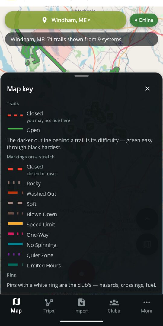
A key, because a coloured line is a claim free
Every kind of marking the clubs use, four trail statuses and five difficulty grades share one map. The key sits on its own button beside the menu, because "what is that red dashed line?" gets asked while you are looking at it.
- Closed trails are dashed as well as red, so the most important distinction on the map does not rest on telling green from red
- Markings carry hours where the club sets them: quiet 10pm – 7am, or a trail that is only open 8am – 6pm
- Each marking sits on the stretch it applies to, not on the whole trail
- The winter words too — ice crossing, open water, thin ice, pressure ridge, slush, bare ground. A club that crosses a lake can say so on the lake, and open water and thin ice stop a route dead rather than warning about it
- The same key, the same colours, on the website
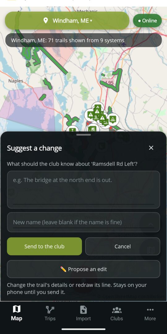
Fix the map from where you are standing free
Ride a reroute that is not on the map and you have two ways to say so. Send the club a note, or propose the edit yourself — redraw the line, change the details, mark the washed-out half mile — and an officer approves it before anyone else sees a thing.
- Anyone signed in can propose. You do not have to be a club member to improve the map
- A proposal stays on your phone until you send it, and off everyone's map until an officer applies it
- Track what you sent in My Contributions, and get told when it is applied or declined — with the reason
- Report a hazard, a condition or a closed stretch the same way, in seconds
A route that knows what you ride free
Pick where you are and where you are going, add the stops you want on the way, and get the route: the miles, the trails it uses, and everything in the way. It routes around closures, seasonal shutdowns and trails your machine is not allowed on — and a stretch it has to cross is drawn in orange and named with the club's own word, not "blocked". Change your machine and the line redraws without a tap.
No estimated time: it tells you the distance and the trails, and leaves the arithmetic about your own riding to you.
And tells you when the short way is shut free
When the quicker way through is closed, the app does not quietly take the long one. It says so, and offers both side by side — 4.2 mi, clear against 2.6 mi, washed out — so the choice is yours. Ask for other ways round at any time and compare what comes back.
Ride it — the turn, and the voice Premium
The next turn on a card, the distance to it, and the turn read out loud so your eyes stay on the trail: “In half a mile, turn right at the intersection onto Corridor 87.” Plus keeping the route for next season — a kept route is stored as its points, not its line, so one saved in November is planned against February's closures when you open it.
Hazard, closure and marked‑stretch warnings are spoken free, route or no route. Planning a route and seeing the whole way through is free too.
Ask what you can't ride free
Loading the truck the night before, you can ask the map what is off limits and get the list: what is closed, what your machine is posted off, and what is out of season — nearest first, each one a tap from the trail itself. Trails belonging to another class are counted rather than listed, because “it was never yours” is a different fact from “you can't ride it today”.
Check it from a browser free
Every club's trail system has a page on this site — the same map, the same colours, the same key, and what is closed right now at the top. No app, no account, nothing to install: send the link to whoever is asking whether the trails are open.
Ride together free
Share your live position with a party for the length of a ride, see everyone on the map with the trail they are on, and share a finished ride with a code. A safety feature behind a paywall is not a safety feature — and when the ride ends, the positions are deleted rather than kept.
Report what you find free
Drop a hazard, report a condition, mark the stretch that is washed out. Submit a trail you rode straight to the club for approval. All free, always: nobody should be charged for improving the map.
Show it, don't just describe it free
Photograph what you found and put it on the pin, the trail or the marked stretch itself. “Washed out” tells a rider the kind of problem; the picture tells them whether they get through. Shoot it there or pick one from your camera roll — out of signal it waits on the handset and uploads when you have bars. Free, on every trail you can see.
Log what you fixed free
Cleared a tree, cut back a corner, dug out a culvert? Log it from the trail with the hours it took, and an officer decides whether it counts. Volunteer hours are match or in‑kind on most grant programmes, so the work stops evaporating at the next meeting.
Your own marks free
Private trails, waypoints and areas only you can see, with your own categories you can lend to a friend by code. Drawing them, editing them and handing one to a club are all free and all work with no signal. They live on the handset; Premium keeps them on your account too.
Follow the clubs free
Club pages, events with RSVP, join requests, and a Recent Updates feed for every system you watch — a closure goes up, a reroute lands, a groomer runs. Watch a single system or a whole region; watching is the consent, and it is free either way.
Told the moment it happens Premium
A closure, a hazard, a new trail, a freshly groomed system — pushed to your lock screen for anything you watch, instead of waiting for you to open the app. Every one of those updates stays free to read in the app's Recent Updates feed; what Premium buys is being told. Officers and trail masters get the pushes free, in any club — alerts about trails are work tooling for the people who maintain trails. The same split holds for riders you follow: what clubs count of theirs is a free feed in the app, and Premium is what puts it on your lock screen.
Your data comes back out free
Export any trail, or any ride of yours, whenever you like — GPX or KML, entitlement or not. Returning your own data is not a feature we would charge for. Taking a whole trail system out at once is the one export that is paid, and it is part of Premium; a club exporting a system it maintains is always free.
The map on your dash Premium
Android Auto and Apple CarPlay put the trail map, the ride controls and the hazard alerts on the head unit — in the truck or built into the machine. What the dash does. Everything it mirrors stays free on the phone.
Somewhere other than one phone Premium
Your rides, your private marks and your saved machines kept on your account, so a lost phone is an inconvenience rather than a loss, and a second device comes up already knowing them. Nothing is capped or deleted without it — it simply stays on the handset.
What the sky is doing free
The forecast for the trail system you are looking at, on the map page — temperature, wind, and the winter numbers that decide a sled day. Free, and it always says how old the reading is, because a stale forecast is the one cached thing in this app a rider would act on.
Data source: NOAA/NWS.
What you have put in free
Trails a club approved, hazards that turned out to be real, hours logged on a work order — they add up to a score, a profile and a place on the board, for your club, your trail system, or everyone. What a club's officer approved is what counts; nothing you can do alone is worth much, which is deliberate.
Your profile is public by default and you can turn that off; a private one is invisible to every board and every feed.
The whole screen, when you want it free
One button hides the app's bars and the phone's, and gives the map about a fifth of the display back. Nothing the map draws over itself goes with them — least of all a closure warning, which is the last thing to take from somebody who just asked for a bigger map.
No ads Premium
The free app carries a small banner on list and detail screens, and one full-screen ad after you finish something — saving a ride, sending a report, submitting an import. Never on the map, never in an editor, never while a ride is recording, never on a volunteer's moderation queue, and never on a head unit. Premium stops both.
On the dash: Android Auto and Apple CarPlay Premium
A lot of machines have a screen now — UTVs ship with head units, riders retrofit standalone ones, and the truck has one for the ride up. Plug the phone in and DynamicTrail puts the same trail map on the dash, sized for gloved hands: big controls, one tap each, nothing to read at speed. Start a route you saved on the phone and the dash follows it — the turn card, the distance to the next one, and the route drawn on the map. Planning one is phone work: it needs a map, a keyboard and a judgement about ground. The phone stays in your pocket doing the work; the dash is the front end.
The second screen is what is paid, never the first. The map, your ride recording and the hazard alerts are free in your hand and stay that way — Premium puts them on the head unit. Plug in without it and the dash says so, rather than showing you nothing.
The same map, bigger
Trails in their status colours, closed stretches dashed red, hazard and amenity pins — gas, food, parking, scenic views — with your position and track on top. The same colours and the same key as the phone and this website, so nothing has to be relearned on the move.
Record without touching the phone
Start, pause, resume and stop from the dash while the phone stays stowed. Drop a waypoint where you are, or start marking a new trail, one tap each.
Alerts as you approach
A hazard ahead — open water, a washout, a blowdown — surfaces on the dash as you close in on it. Once, then it stands down; a screen that nags gets ignored.
Follow a route you planned
Start one of your saved routes from the dash and it draws on the map with the next turn on a card and the distance to it, spoken as you come up on each one. Planning stays phone work — placing points needs a map, a keyboard and a judgement about ground — so the dash follows a route, it never plans one.
Knows your machine
The riding mode you picked on the phone comes with you, so the dash greys out trails your machine is not allowed on and tells you which posting says so — the same restrictions the clubs put on the map.
Browse the trails from the dash
The trail list, a trail's detail and its description, in the order that answers the rider's question first. And the map key on its own button, because the colours mean the same thing on a head unit as they do in your hand.
Offline, like everything else
The dash draws from the same offline package and cache as the phone, so it keeps working with no bars. Pan, pinch to zoom and recentre; night mode follows the head unit.
Both platforms, built together. Android Auto arrives with the Android app; Apple CarPlay is built alongside it and arrives with the iOS app. They run the same map renderer, the same recording controls and the same hazard alerts — the two differences are Apple's, not ours: CarPlay gives an app no way to receive a tap on the map itself (the trail list is the way in) and no free-text slot for a live elapsed/distance line.
For clubs
Moderation is free forever — approving, editing and reviewing what riders send is the work that makes the map, and taxing volunteers for it would be backwards. So is everything else on this list.
Approve what becomes official free
A queue of everything riders submitted, with the map to check it against. Approve, decline with a reason the rider actually sees, and undo any of it from the trail's history.
Maintain the trails free
Edit, reroute, split, mark a stretch, close a section, restore something deleted by mistake — from the office or standing on the trail with no signal.
Review what riders propose free
A rider's proposed edit arrives as a diff, not a paragraph: status, difficulty, length, activity types added or removed, how many points moved on the line. Compare the routes on the map, then apply, apply with your own changes, or decline with a reason the rider sees. Nothing they send is visible to anybody until you do.
Every version kept free
Each change writes down what the trail looked like before it. Read the history, see what each entry would put back, and restore any of it. Restoring is itself undoable, so a bad approval at 11pm is a two-tap problem.
Mark a stretch, not a trail free
Closed, washed out, soft, blown down, rocky, one-way, no spinning, a speed limit, quiet hours, open hours — each drawn on the half mile it applies to, with its own colour and stroke and a shelf life, so a condition nobody remembers stops lying to riders on its own. Admins can add types.
Roster and join requests free
Members, officers and trail masters, each with the right level of access, and riders asking to join from the trail page. Membership is the top of your funnel; charging for it would be charging you to grow.
Groomer positions, live free
A groomer's run shows on the rider map while it happens, if the club wants it to — public, members only, or off. It is the reason riders open the app on a winter morning, and it is safety information, so it is not for sale.
Trail work and volunteer hours free
What needed doing, who did it, and how long it took — logged by the rider who did the work or dispatched by the club. Hours are recorded straight away and count towards nothing until an officer says so. Acknowledging the work and counting the hours stay separate decisions: a club is often glad a tree was cleared and still cannot claim the hours for it.
Photos, without a queue to work free
Riders can photograph any trail, pin or marking they can see. Photos appear immediately, then age off after a week unless an officer keeps one — so a club that never opens the feature accumulates nothing. Your own photos stay as long as the record does.
Bulk import free
Bring a whole archive in from GPX or KML, name and describe it, fix the lines, then send it for approval in one pass. Getting a club's existing trails onto the map is the work that makes the map worth having — charging for it would be charging for the thing we want to happen.
Work from a browser free
Upload an archive, work the pending queue and edit a club's details from a desk, on this site, with no app installed. Everything that changes club data is free here for the same reason it is free in the app.
Premium seats for your officers free
Every club has three Premium seats for its officers and trail masters, on us — nothing a club pays for. The people doing the club's work should not be paying for the app they do it in. Ask us to seat yours.
Every feature, and what it costs
The whole list, with no marketing in it. If something you rely on is going to ask you for money later, it says so here.
| Feature | Price |
|---|---|
| The map | |
| The club-maintained map Trails, waypoints, areas, parcels, conditions, clubs, events, sponsors | free |
| Trail filters and the map keyFilter by activity, status and difficulty; the key on its own button | free |
| Riding modePick your machine; ineligible trails dim and name the posting that says so | free |
| Warnings as you come up on thingsA closure, a washout, a speed limit, a gate too narrow for your machine, a trail it is not allowed on — on screen and read out loud, once each. Free whether or not you are following a route | free |
| Saved machines across devicesSeveral machines with their specs, kept on your account and switchable | Premium |
| Contour overlayTerrain relief under the trail layer | free |
| Zoom, at every levelNever gated, online or off. A hazard pin has to land on the right side of a junction | free |
| The same map in a browserEvery trail system has a public page here — no app, no account | free |
| Finding your way | |
| Plan a route and see the whole way throughPick where you are and where you are going, add stops, and get the miles, the trails it uses and everything in the way. Closures and postings are routed around, and the ones it cannot avoid are named | free |
| Other ways roundAlternatives to compare, and the shorter one that is shut said plainly | free |
| Ride it — turn-by-turn, spokenThe next turn, the distance to it, and a voice that reads it out so your eyes stay on the trail | Premium |
| Keep a routeSaved as its points, not its line, so one kept in November is planned on February's closures when you open it | Premium |
| Off the grid | |
| One offline regionAbout 100 MB, downloads on wi-fi. Switchable free, and always free to keep current | free |
| Several offline regions at onceFor trailering out of state without swapping maps first | Premium |
| Club trails, waypoints and closures offlineReading them, and an officer editing them, with no signal | free |
| On the dash | |
| Android AutoThe map, ride controls, waypoint drop, hazard alerts, trail list and key | Premium |
| Apple CarPlayThe same, on the iOS app, built alongside it | Premium |
| The map and hazard alerts in your handWhat the dash mirrors. Free with or without a head unit — Premium buys the second screen, not the information on it | free |
| Your rides | |
| Recording, pause and resumeKeeps running with the screen locked and the phone in a pocket | free |
| Draw a ride, import GPX and KMLBring years of history in from wherever it is now | free |
| Editing, marking and exporting a rideEdit the path, mark a stretch, export GPX or KML | free |
| Submitting a segment to a club as a trailWith your markings on it, clipped to the stretch you picked | free |
| Sharing a ride by code, and redeeming oneBoth directions | free |
| Rides kept on your accountSurviving a lost phone and appearing on a second device. Without it a ride simply stays on the handset — never capped, never deleted | Premium |
| Riding together | |
| Group rides and live location sharingParty members on the map with the trail each is on. Positions are deleted when the ride ends | free |
| Live groomer positionsWherever the club shares them | free |
| Making the map better | |
| Hazard, condition and closure reportsIncluding photos, and including with no signal | free |
| Submitting trails, waypoints and areas to a clubYou do not have to be a member | free |
| Proposing an edit to an official trailRedraw the line or change the details; an officer applies it | free |
| Reviews, ratings and My ContributionsWhat you sent, and what the club decided, with the reason | free |
| Volunteer hour loggingFrom the trail, with the hours it took | free |
| Your own marks | |
| Private trails, waypoints and areasDrawing them, editing them and handing one to a club — all offline too | free |
| Your own waypoint categories, lent by codeYour vocabulary, on a friend's phone | free |
| Your marks kept on your accountSurviving a lost phone and appearing on a second device | Premium |
| Being told | |
| Watching a system, or a whole regionThe consent, and it stays free whether you subscribe or not | free |
| A system's Recent Updates feedClosures, hazards, new trails and grooming, 90 days, in the app | free |
| Push notifications for what you watchThe same updates, on your lock screen, as they happen. Free for officers and trail masters of any club | Premium |
| Club pages, events and RSVPsViewing and replying | free |
| Getting your data out | |
| Exporting a single trail, or one of your ridesGPX or KML | free |
| Exporting a whole trail systemPart of Premium. Free for a club exporting a system it maintains, and exporting a single trail is free for everyone | Premium |
| Ads | |
| An ad-free appPart of Premium. The free app shows a small banner on list and detail screens and one full-screen ad after you finish something — never on the map, in an editor, while recording, on a moderation queue, or on a head unit | Premium |
| Nothing you do in the app targets advertisingYour location, your rides and your marks are never given to an ad network. What the ads SDK sees is your device's advertising ID and general device information, and where consent rules apply you are asked first and can change your mind in Settings | free |
| Club: making the map | |
| The approval queueApprove, decline with a reason, and undo | free |
| Reviewing a rider's proposed editAs a diff, with the routes compared on the map | free |
| Editing, rerouting, splitting and restoring trailsWith the full history behind it, and offline in the field | free |
| Marking stretches and closing sectionsMarking types with colours, strokes, hours and a shelf life | free |
| Bulk GPX and KML importA whole archive, named, fixed and submitted in one pass | free |
| Roster, join requests and rolesMember, officer, trail master | free |
| Broadcasting live groomer positionsPublic, members only, or off | free |
| Accepting volunteer hours, and dispatching workAcknowledging the work and counting the hours stay separate decisions | free |
| Rider photos, and keeping the ones that matterThe rest age off after a week on their own | free |
| Working from a browserUpload, pending queue and club details on this site | free |
| Exporting a system the club maintainsNever charged back to the volunteers who put the data in | free |
| Premium seats for officersThree per club for officers and trail masters, on us | free |