Your trail network is alive. Manage it like it is.
Washouts happen overnight. Permits change mid-season. A bridge closes and nobody knows until a rider hits it. DynamicTrail gives your club the tools to keep everyone current — from the office and from the trail.
The club tools on this site work today — start loading your trails now, and your riders open a finished map on day one. Everything a club gets.
How clubs manage trails today
Announcements that scroll away
A closure posted on Tuesday is buried by Thursday. Riders show up at washed-out sections anyway, and your volunteers answer the same question all weekend.
PDFs nobody updates
The trail map from 2019 is still floating around. The reroute from last spring isn't on it.
Word of mouth that doesn't scale
Your Trail Master knows everything. What happens when they're unavailable?
A closure that takes a week to reach anyone
A bridge goes out on Saturday. The people who need to know are riding towards it on Sunday. Whatever you update, and wherever, none of it reaches a phone at the trailhead.
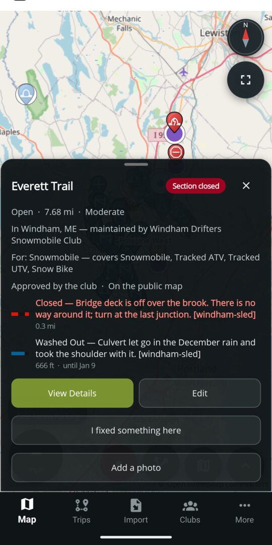
All four of those, answered on one card
Tap a trail and you get what the club put there, in their own words: the bridge deck is off over the brook, there is no way around it, turn at the last junction. Below it, a culvert that let go in the rain — and that one carries a date, so it stops warning riders once it is fixed.
- The closure sits on the 0.3 miles it applies to, not on the whole 7.68-mile trail
- Conditions carry a date, so what you posted after a storm stops warning riders once it is fixed
- It names the club that maintains it — your ground, with your name on it
- A rider reads it at the trailhead with no signal, because the trails are already on their phone
One place your whole club lives
DynamicTrail isn't a map. It's the ground truth your club maintains — and the app your riders actually check before they head out.
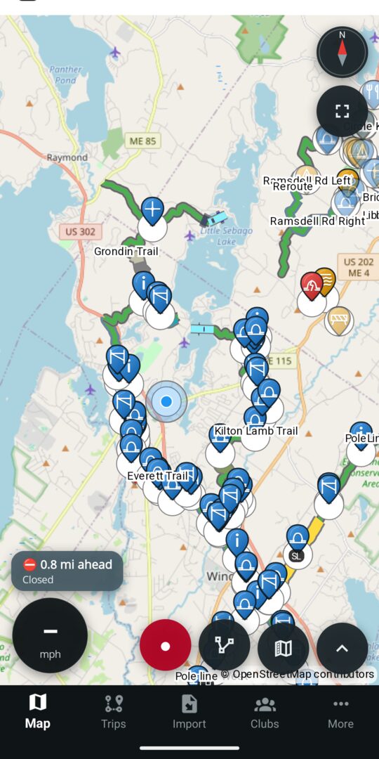
Your trails, named, with what is wrong on them
The lines are the club's, and so are the names on them. The chip at the bottom is the app telling a rider what is 0.8 miles ahead — before they get to it, and without being asked.
- Parking, warming huts, gates and hazards as pins riders can tap
- A marked stretch is drawn on the stretch, with its own colour and letters
- Neighbouring clubs' systems draw alongside yours, so a ride that crosses a boundary still looks like one map
- The same map, the same colours, on a public page on this site — send the link to anyone asking whether the trails are open
Trail status in real time
Mark a section open, closed, or restricted from your phone. Everyone sees it immediately.
Hazard pins that expire
Drop a mud waypoint after a storm. Set it to expire in 72 hours. No stale warnings piling up.
Official vs. contributed
Members submit new trails. Your Trail Master reviews and approves. Riders see what's verified.
Club member roles
Trail Master, member, contributor — each role with the right level of access. No more shared logins.
Works offline in the field
Your crew can update trails from places with no signal. Everything queues and syncs when back in range — and it costs nothing. Volunteers doing unpaid work for their club should never meet a paywall in the woods.
Volunteer hours you can count
A rider clears a blowdown and logs the time from the trail. An officer decides whether it counts. Match or in‑kind on most grant programmes — so the work already being done stops evaporating at the next meeting.
Rider photos, no queue to work
A rider photographs the washout; everyone sees it at once. It ages off after a week unless an officer keeps it, so ignoring the feature costs you nothing and piles up nothing.
Close a trail the moment it happens
Permit pulled mid-season? Bridge washed out overnight? Mark it closed, restricted, or seasonal from your phone. Riders see it before they leave the trailhead.
How a fix reaches the map
This is the loop the whole product is built around, filmed in the shipping app and sped up. A rider marks what they found; nothing reaches the map until somebody with standing in the club decides it should. Both halves are free, and neither needs the rider to be a member of anything.
A rider marks what they found
The ledge above the brook has come bare, so they mark that stretch Rocky, set how long it should last, and write the club a line about it. The trail already carries the club's own closure and washout; this goes on top of them, on the half mile it applies to.
- Tap the trail. The club's closure and washout are already on it
- Open its details — a rider gets Suggest a change where an officer gets Edit
- Pick the stretch off the trail itself, start and end
- Say what it is — Rocky — and when it should clear on its own
- Write the club a line about it
- Send it. Nothing on the map changes yet, and the app says so
A screen recording of the shipping app, sped up. No sound — the steps above are the whole commentary.
An officer decides
It arrives on the club's own page as a difference, not a paragraph: markings 2 → 4, on Everett Trail, with the rider's words underneath. Apply it, apply it with your own changes, or decline it with a reason the rider actually sees.
- The club's page — who maintains this ground, and what is waiting on it
- The suggestion as a diff, with the rider's note under it
- Apply. The dialog says it can be undone from the trail's history
- Queue clear, and the marking is on the club's trail
Nothing a rider sends is visible to anybody until this happens.
Your club, fully in your control
DynamicTrail isn't just about trails. It's the home base for your whole club — your profile, your people, and the partners who make it all possible.
Club profile you own
Update your club name, description, contact info, and logo any time — no waiting on a webmaster. What riders see on the app is exactly what you put there, the moment you save it.
Member roster that stays current
See who's in your club, manage their roles — Trail Master, volunteer, contributor — and invite new members directly. No spreadsheet, no email chain, no guessing who has access to what.
What it costs
Everything that makes the map work is free — for your riders and for your volunteers. No card, no clock.
Free for every club
Nothing to buy.
- ✓ Your trail system on the map, maintained by you
- ✓ Approve, decline and edit what riders submit
- ✓ Reroute, split, mark stretches, close sections, undo any of it
- ✓ Work offline in the field and sync when you are back
- ✓ Roster, join requests and live groomer positions
Already have your trails in a file?
Most clubs do — a GPX export from somebody's handheld, a KML somebody drew years ago, a folder of both that has been passed between three trail masters. Any of it is a starting point, and none of it has to be tidy.
Do it yourself, free
Bulk import is in the app and costs nothing. Bring the whole archive in, name and describe the trails, fix the lines, and send them for approval in one pass. If you would rather keep your hands on it, this is the way.
Or upload it here
Sign in, pick the trail system, choose your files. You see everything the file holds and name it before any of it is sent — then every track becomes a trail waiting in that club's approval queue. No app, no install, and you do not have to hold any office in the club to send one.
Nothing goes on the map until somebody with approval rank in the club has accepted it, item by item. An upload is a request, not a publication — which is why it is safe to let anyone signed in send one.
Get your club on early access
We're onboarding a small number of clubs to help shape the product. If you manage trails and are tired of keeping the same map in three places at once, we want to hear from you.
You'll create an account first — that's what lets us let you straight in once your network is loaded. Then it's one page: your club and its board, what you do there, and each of your trail systems with the towns it runs through. Bring your GPX or KML if you have one and we'll import it for you. We answer every one.